Overlay #1: The Marquette Plan

Aerial of the South Shore of Lake Michigan:
For some reason the Marquette Plan is a relatively unpopular initiative in East Chicago leadership circles. Why, I do not understand. With a city that occupies about 12 square miles with about 40% of that land presently out of production (due to contamination or the impression of, consolidation of the steel industry or simply the last 20 years of local businesses filing for bankruptcy), you would think an opportunity like this would fetch more support. The Marquette Plan is an open vision (the bigger/the more visionary/the more unique - the better) for our childrens inheritence. Let's don't blow it by not thinking or thinking so small. This is the opportunity to think big, real big, 20 billions dollars worth of big.
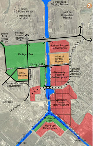
Sub Area Plan for East Chicago:
The Indiana Harbor Ship Canal (The greatest geological feature on the southern shores of Lake Michigan.
Near-term Projects as Identified by the Marquette Plan (next 3-5 yrs)
Catalytic Projects for East Chicago:
#3 Industrial Bridge and Beachfront Park
- Construct new vehicular bridge that connects Cline Avenue to Ispat Inland and former ISG properties to the north.
-Assess feasibility of re-using existing ISG Bridge for public lakefront access
-Develop new public parkland on Land transferred from former ISG including an existing beach and lakefront frontage.
#4 Jeorse Park Improvements
- Relocate casino employee parking to alternative lot to improve public access to existing park
- Improve public amenities at Jeorse Park, including trails, landscaping and support facilities
- Link park to Gary casino at Buffington Harbor
Planning Initiatives
B. Whiting/ EC Lakefront
- Explore feasibility of relocating existing BP water purification facilities to a consolidated site south of railroad tracks.
- Prepare master plan and development guidelines that integrates Whilhala Park, Whiting Park, reclaimed BP water purification property, ISG beachfront and Marktown "Heritage Park"
E. Canalway Master Plan
-Explore the feasibility of realigning elevated sections of Cline avenue to connect with proposed new industrial access bridges to Ispat Inland Steel and former ISG property. This effort should study the impacts to lowering the roadway to a more suitable height that maintains grade separation over active railroad tracks while fitting better into the surrounding community and demolishing unneeded sections east of the shipping canal to create additional community development areas.
- Prepare a community Master Plan for the proposed Canalway neighborhood to determine the most appropriate land use mix for existing and reclaimed parcels and to calculate economic benefits, including tax revenue and job creation.
NOTE:The Marquette Plan represents Billions of re-investment dollars in our Lakefront, and East Chicago missed the deadlines for funding projects in 2006. A matter of fact no one in the administration even knew what opportunities the Marquette Plan represented for the City nor what deadlines where set. Let me speak loudly. The next deadline is in December for projects in 2007. I have yet to hear of any plans coming from the city besides a short bike path on the lakefront. With such lack of vision, let me offer you some ideas. To come>>>>
The Question is what is the Marquette Plan?
- What are the benefits?
- What are the opportunity cost (cost/benefit analysis) ?
- Why should East Chicago move forward with this Plan?
- Why are City Leader so reluctant to adopt the Plan or at least the values set out in the Plan?
posted by Thomas at 12:48 PM
![]()
![]()

2 Comments:
You have a picture of the proposed area of consideration, but I can't figure out what exactly are the boundaries that would effect the residents. When you speak of COmprehensive planning ,has the community been questioned or in any way involved in this plan since eventually they are the ones that are going to end up paying for it one way or another. Also, I would like to know why Frank Kolintzas is writing about the future plans of East Chicago and his vision of the future of East Chicago when he was directly responsible in many ways for the decisions made up to this point?
Yes, much of what the Marquette Plan proposes is a strategy to bring re-investment to our waterways. This includes the Lakefront, the Indiana Harbor Ship Canal, and the Grand Calumet River. Recognizing that most of industry had resided along our waterways the Marquette plan also functions as a Brownfield redevelopment plan. In some areas you can see that the neighborhood grid is extended to the waterfront. In other areas the Marquette Plan provides a buffer between incompatible uses such as neighborhoods and the industry that is consolidating up the peninsula. This brings multiple uses to our waterways, and encouraging environmental responsibility.
The Marquette Plan is essentially the first regional land use plan, and the first opportunity for these older industrial communities on the lake to create their own identities. The Marquette Plan included public meetings in each of the lakefront communities from Hammond to Portage.
If you are speaking about East Chicago's Comprehensive Plan, the process has yet to begin. The intension is to have a very public dialogue on creating a vision for the future of the communities built environment.
Who pays for it is another issue. In some areas the city may use Federal dollars to seed private investment. Elsewhere they may use Casino money earmarked for redevelopment. They may also seek Marquette, RDA and Empowerment dollars, or create tif districts. Unlike building schools or a police stations, housing and community projects tend to leverage the local market to attract development with the cities providing infrastructure. At this point all I can say is that East Chicago will probably use all the above financial strategies.
Post a Comment
<< Home